

Go to modelshipwrights.com for the current dynamic site!


Speed Measurement in the Age of Sail
2
Comments

"MSW Crew-mate Wink Grise (Rokket2001) shares a bit of Nautical history with us, with a tool, and the method used, in the age of sail, to determine navigational speeds."
The Log Line: Speed Measurement in the Age of Sail
In the Age of Sail, knowing your speed was critical. Speed meant navigation. If you didnt know how fast you were sailing you didnt know where you were, because speed is really the distance travelled in a certain amount of time.
Without GPS and autopilot, sailors had to keep a manual record of speed and course to determine (approximately) where they were. They recorded everything to a peg board called a traverse or travass board. At the end of the watch they transferred the information to charts and a log book. This type of navigation is still used today and is called ded reckoning (from deduced).
Direction was easy. You had the sun and the stars. If you couldnt see either of those, there was the compass. No one knows for sure when it was invented, but it seems to have been first used by mariners in the late 1100s in the Mediterranean. (There is evidence that suggests the Chinese may have been the first to use compasses.)
But speed was more difficult. Until about 1500, sailors would guestimate speed by dropping wood or any debris into the water and counting how long it took the ship to pass by the debris. If a ship was 100 feet long and it took 25 seconds to pass some floating scrap, the ships speed would be 240 feet a minute:
60 seconds / 25 seconds = 2.4
2.4 x 100 feet = 240 feet
Or 14,400 feet an hour (240 feet x 60 mins). English miles were 5,000 feet, so that example equals just under 3 Age of Sail miles per hour, an all too common speed for loaded merchantman of 200-ton cargo capacity.
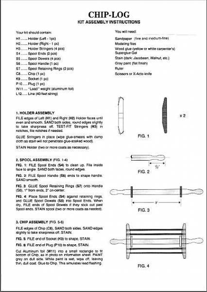
The guestimate method was good in principle, but not neat and precise. By the 1570s the method was improved slightly with a new tool, the log line, sometimes called the chip log. Some historians believe it was invented by the English, others the Dutch. Instead of debris, a board (also called chip or log) was tossed out. The board was roughly the size of a large clipboard today, but thicker, and weighted at the bottom with a lead strip. The chip was tied to a spool of line, and when tossed out behind the ship, the weight at the bottom kept it upright, and this made it resistant to being pulled along. Something like trying to pull a bucket through water, or a sea anchor. The ship continued travelling as the chip sat stationery, and the line paid out. Sailors counted how much line paid out in various time periods.
This probably doesnt seem like much of an improvement to the old method. It wasnt, according to many mariners. Handling the line and timing it accurately were difficult. One minor improvement was to add a stray line at the beginning of the spool, so the board had time to get out past the wake. Another improvement was to add crows feet tackle, or a triangle connection with a wooden socket, so that when measurement was complete, a tug would pull the main line from the socket and the board would collapse flat for easy hauling aboard.
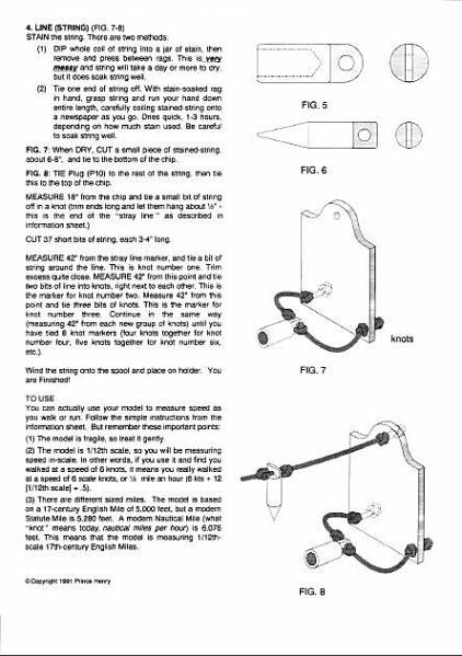
In 1619 Edmund Gunter, an English mathematician, proposed further improvements in a series of lectures. The lectures mustnt have been received with joy straight away, because he was still proposing and refining in 1623. Gunter suggested standardizing the time measurement to a definite 30 seconds, to be measured with a sandglass. He chose 30 seconds because that equals 1/120th of an hour. If the line were marked off with a knot tied in it in the same proportion every 1/120th of a mile - then using the log would give a direct reading. For example, if a sailor counted three knots passing through his hand in 30 seconds, then he was travelling three miles per hour, or three knots. This is where the term knots originated. Today knot means nautical mile, defined internationally since 1929 as 6,076 feet (1,852 meters) or one minute of arc on the equator.
By 1632 the log-line was well established, and the French explorer Samuel Champlain published a book praising it. Later Richard Norwood added another improvement, bits of leather in the line for half-knots, and multiple knots for each successive mile counted: one knot for one mile per hour, two knots for two, etc. The log line was used successfully for many years.
In 1729 a marine Surveyor, Henry Saumarez, invented a rotating log. Similar in principle to the chip log, it was a Y shape propeller that rotated as it was pulled, with revolutions counted aboard ship by a small wheel.
A year later, Henry Pitot proposed a radical idea: an L shaped tube attached to the hull. Water would be forced into the tube as the ship travelled. The higher up the tube the water was pushed, the faster the ship travelled. Because the idea was brilliant (compact, simple), it was of course discouraged and put aside for 150 years.
In 1802 Edward Massey varied the rotating Y by splitting it into two mini-rocket/fin tubes hooked together with linkage, which translated rotations into dial registers. It was fairly accurate and easy to use, and was very popular for most the century.
In 1861 Thomas Walker improved the Massey log by putting the dials aboard ship. Different forms of this principle are still used today, making only a compact bump on the hull.
In the late 1880s someone dusted off the pitot tube idea and put it to use. Along with rotating logs, it was very popular and variations (water to air pressure) are still used today, even in aircraft to measure airspeed. The future...is GPS, though simple mechanical backups will always be a good idea.
SOURCES
The Art of Navigation
DW Waters, Yale University Press, 1958
Seamans Secrets
John Davis (16-century), Samuel Morrison edition
A History of Marine Navigation
WE May, WW Norton & Co, 1973
Duttons Navigation and Piloting
US Naval Institute, 1967
The Lore of Ships
Janne Lundbladh (ed.), Gallery Books, 1990
The Mapmakers
John Noble Wilford, Alfred A Knopf, Inc., 1981
Practical Celestial Navigation
Susan P Howell, Mystic Seaport, 1987
The Visual Dictionary of Ships and Sailing
Roger Tritton (ed.), Dorling Kindersley, 1991
Edit. note:
Wink produced this model subject in kit form a few years back for sale in the U.S. before he relocated to Australia, and has provided the original instruction sheet for any modeler who wishes to try his hand at scratch-building the subject...he has stated that maybe one day he may begin to reproduce the kit again, in his new home, down under! I am publishing the sheet here in this article, but if you're seriously wishing to give this a try and would like a .pdf version, drop me a line here and I can send you the file.
The Log Line: Speed Measurement in the Age of Sail
In the Age of Sail, knowing your speed was critical. Speed meant navigation. If you didnt know how fast you were sailing you didnt know where you were, because speed is really the distance travelled in a certain amount of time.
Without GPS and autopilot, sailors had to keep a manual record of speed and course to determine (approximately) where they were. They recorded everything to a peg board called a traverse or travass board. At the end of the watch they transferred the information to charts and a log book. This type of navigation is still used today and is called ded reckoning (from deduced).
Direction was easy. You had the sun and the stars. If you couldnt see either of those, there was the compass. No one knows for sure when it was invented, but it seems to have been first used by mariners in the late 1100s in the Mediterranean. (There is evidence that suggests the Chinese may have been the first to use compasses.)
But speed was more difficult. Until about 1500, sailors would guestimate speed by dropping wood or any debris into the water and counting how long it took the ship to pass by the debris. If a ship was 100 feet long and it took 25 seconds to pass some floating scrap, the ships speed would be 240 feet a minute:
60 seconds / 25 seconds = 2.4
2.4 x 100 feet = 240 feet
Or 14,400 feet an hour (240 feet x 60 mins). English miles were 5,000 feet, so that example equals just under 3 Age of Sail miles per hour, an all too common speed for loaded merchantman of 200-ton cargo capacity.
The guestimate method was good in principle, but not neat and precise. By the 1570s the method was improved slightly with a new tool, the log line, sometimes called the chip log. Some historians believe it was invented by the English, others the Dutch. Instead of debris, a board (also called chip or log) was tossed out. The board was roughly the size of a large clipboard today, but thicker, and weighted at the bottom with a lead strip. The chip was tied to a spool of line, and when tossed out behind the ship, the weight at the bottom kept it upright, and this made it resistant to being pulled along. Something like trying to pull a bucket through water, or a sea anchor. The ship continued travelling as the chip sat stationery, and the line paid out. Sailors counted how much line paid out in various time periods.
This probably doesnt seem like much of an improvement to the old method. It wasnt, according to many mariners. Handling the line and timing it accurately were difficult. One minor improvement was to add a stray line at the beginning of the spool, so the board had time to get out past the wake. Another improvement was to add crows feet tackle, or a triangle connection with a wooden socket, so that when measurement was complete, a tug would pull the main line from the socket and the board would collapse flat for easy hauling aboard.
In 1619 Edmund Gunter, an English mathematician, proposed further improvements in a series of lectures. The lectures mustnt have been received with joy straight away, because he was still proposing and refining in 1623. Gunter suggested standardizing the time measurement to a definite 30 seconds, to be measured with a sandglass. He chose 30 seconds because that equals 1/120th of an hour. If the line were marked off with a knot tied in it in the same proportion every 1/120th of a mile - then using the log would give a direct reading. For example, if a sailor counted three knots passing through his hand in 30 seconds, then he was travelling three miles per hour, or three knots. This is where the term knots originated. Today knot means nautical mile, defined internationally since 1929 as 6,076 feet (1,852 meters) or one minute of arc on the equator.
By 1632 the log-line was well established, and the French explorer Samuel Champlain published a book praising it. Later Richard Norwood added another improvement, bits of leather in the line for half-knots, and multiple knots for each successive mile counted: one knot for one mile per hour, two knots for two, etc. The log line was used successfully for many years.
In 1729 a marine Surveyor, Henry Saumarez, invented a rotating log. Similar in principle to the chip log, it was a Y shape propeller that rotated as it was pulled, with revolutions counted aboard ship by a small wheel.
A year later, Henry Pitot proposed a radical idea: an L shaped tube attached to the hull. Water would be forced into the tube as the ship travelled. The higher up the tube the water was pushed, the faster the ship travelled. Because the idea was brilliant (compact, simple), it was of course discouraged and put aside for 150 years.
In 1802 Edward Massey varied the rotating Y by splitting it into two mini-rocket/fin tubes hooked together with linkage, which translated rotations into dial registers. It was fairly accurate and easy to use, and was very popular for most the century.
In 1861 Thomas Walker improved the Massey log by putting the dials aboard ship. Different forms of this principle are still used today, making only a compact bump on the hull.
In the late 1880s someone dusted off the pitot tube idea and put it to use. Along with rotating logs, it was very popular and variations (water to air pressure) are still used today, even in aircraft to measure airspeed. The future...is GPS, though simple mechanical backups will always be a good idea.
SOURCES
The Art of Navigation
DW Waters, Yale University Press, 1958
Seamans Secrets
John Davis (16-century), Samuel Morrison edition
A History of Marine Navigation
WE May, WW Norton & Co, 1973
Duttons Navigation and Piloting
US Naval Institute, 1967
The Lore of Ships
Janne Lundbladh (ed.), Gallery Books, 1990
The Mapmakers
John Noble Wilford, Alfred A Knopf, Inc., 1981
Practical Celestial Navigation
Susan P Howell, Mystic Seaport, 1987
The Visual Dictionary of Ships and Sailing
Roger Tritton (ed.), Dorling Kindersley, 1991
Edit. note:
Wink produced this model subject in kit form a few years back for sale in the U.S. before he relocated to Australia, and has provided the original instruction sheet for any modeler who wishes to try his hand at scratch-building the subject...he has stated that maybe one day he may begin to reproduce the kit again, in his new home, down under! I am publishing the sheet here in this article, but if you're seriously wishing to give this a try and would like a .pdf version, drop me a line here and I can send you the file.


About the Author


FROM: SOUTH AUSTRALIA, AUSTRALIA
45 yr old Yank/Aussie in Oz.. Started with WWII models at 12, 1 scratchbuilt power station at 14, then eventually Star Trek and space. Been out of it for awhile, rediscovering WWII. Trying to improve airbrushing and weathering skills.
Comments


Copyright ©2021 by Wink Grise. _OPINIONS Model Shipwrights, KitMaker Network, or Silver Star Enterrpises. Images also by copyright holder unless otherwise noted. Opinions expressed are those of the author(s) and not necessarily those of Model Shipwrights. All rights reserved. Originally published on: 2008-03-18 00:00:00. Unique Reads: 9579

WEB HOSTING BY


Copyright ©2021 Model Shipwrights and Kitmaker Network, a subsidiary of Silver Star Enterprises
All Rights Reserved. Please read our Conditions of Use and Privacy Policy.
All Rights Reserved. Please read our Conditions of Use and Privacy Policy.